This is day 15 of "One CSV, 30 stories":http://blog.whatfettle.com/2014/10/13/one-csv-thirty-stories/ a series of articles exploring "price paid data":https://www.gov.uk/government/statistical-data-sets/price-paid-data-downloads from the Land Registry found on GOV.UK. The code for this and the other articles is available as open source from "GitHub":https://github.com/psd/price-paid-data
Following on from "yesterday":http://blog.whatfettle.com/2014/11/07/one-csv-thirty-stories-14-hackday/'s hackday I had a spot of breakfast with "Michael":https://twitter.com/mikiee_t. I tweaked the map from "Day 13":http://blog.whatfettle.com/2014/11/06/one-csv-thirty-stories-13-postcodes/ to "scale the size of each postcode":https://github.com/psd/price-paid-data/commit/38bedba7c6d07d8397380780a1a62d81c48c2236 using the total volume of transactions over 20 years:
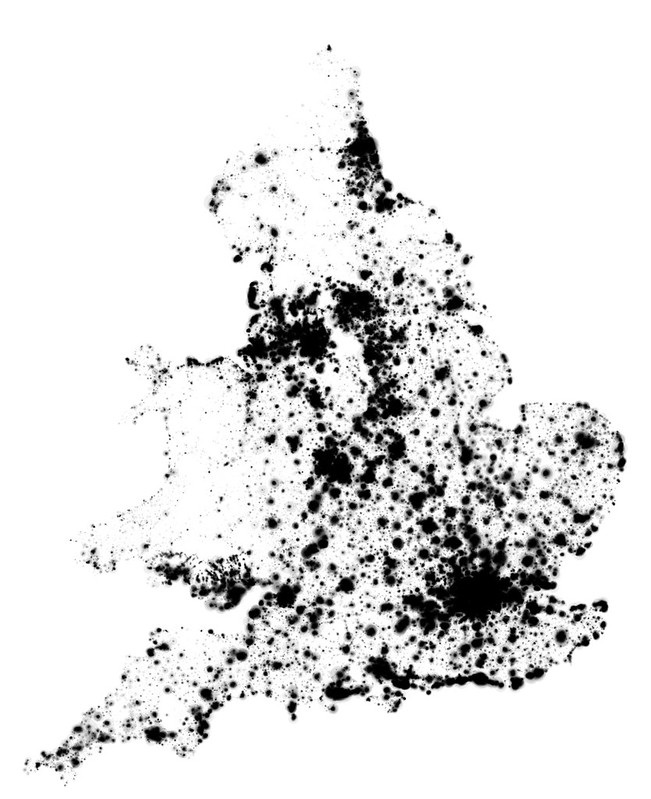
Michael quickly turned this image into a second poster [PDF] before dashing to the station.
I'm cock-a-hoop how this image has turned out. The detail looks like bacteria on a petri-dish, but zoomed out it's apparent not just where people live, but where people buy and sell houses the most, with the coast of East Anglia, Eastbourne and Cornwall darker than you'd expect. I can guess this may be due to turnover of retirement homes or holiday cottages but it's plain to see there are many more interesting stories begging to be discovered from this simple map weighted with other open data from the likes of the "ONS":http://www.ons.gov.uk/.
This afternoon I'm on a train travelling back from Plymouth which means several hours "without access to the interwebs":en.wikipedia.org/wiki/Communications_blackout — an ideal opportunity to "iterate this hack":http://blog.whatfettle.com/2014/11/11/one-csv-thirty-stories-16-mapination/.